Vintage landscape: Washington Monument, Baltimore, Md.

Great Washington, too, stands high aloft on his towering main-mast in Baltimore, and like one of Hercules’ pillars, his column marks that point of human grandeur beyond which few mortals will go.

— Herman Melville, Chapter XXXV, Moby Dick

Washington Monument, Baltimore, early 19th c., Library of Congress/enclos*ure
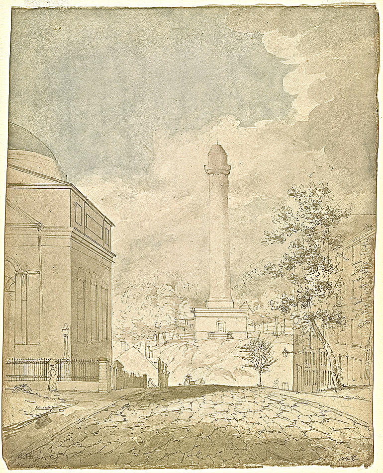
Above: Baltimore’s Washington Monument under construction in 1828 (looking north).  A watercolor, ink, and graphite drawing by John Rubens Smith, via the Library of Congress.*

Completed in 1829, the monument was the second one erected to honor George Washington.  (A tower in Boonsboro, Md., was finished first, in 1827.)

The land for the 178′ tower and its surrounding park had been donated by John Eager Howard from part of his estate, Belvidere.  In the late 18th century, Belvidere was often praised for its fine high views, and the monument was originally visible from ships entering the harbor (today, 10 city blocks to the south).

1796 George Beck Baltimore from Howard Park, Maryland Historical Society. 
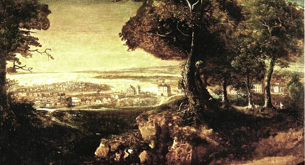
Above: Detail of “The View of Baltimore from Governor John Eager Howard’s Garden Park,” 1796, via the Maryland Historical Society and Early American Gardens.

19th c. Washington Monument, Baltimore, Library of Congress/enclos*ureAbove: In 1849, artist unknown.

During the next twenty years, four small squares, one in each direction, were laid out around the monument.  They were originally planted with grass and surrounded by iron fences.  The well-to-do built homes, churches, and cultural institutions around the squares, which became known collectively as Mount Vernon Place.

“It [was] one of the first examples in the United States of a deliberate use of city planning to create a dramatic setting for an existing monument,” according to the Trust for Architectural Easements.

Washington Monument, Baltimore, 1900, Md. Historical Society/enclos*ure
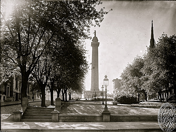
Above: Mount Vernon Place, east side, 1900, photographer unknown.

Mount Vernon Place has undergone several design and planting changes since about 1850, according to the Mount Vernon Place Conservancy.  The photo above and those below show the 1875-76 paths and stone walls of Frederick Law Olmsted’s firm.

early 20th c. Washington Monument, Baltimore, Library of Congress/enclos*ure
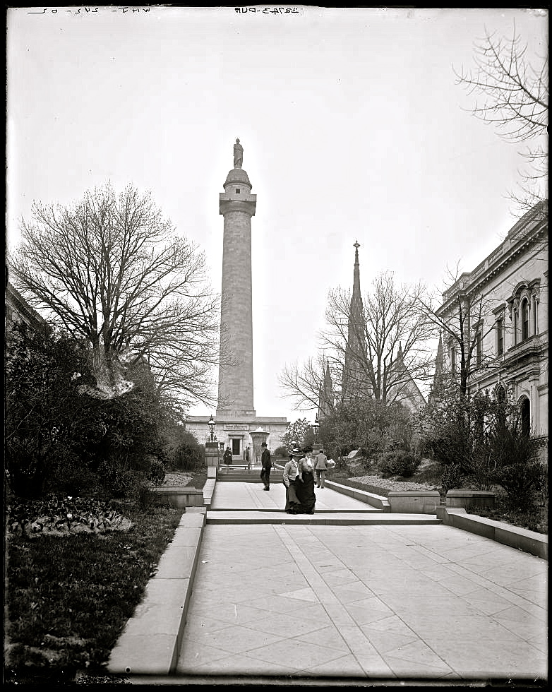
Above:  The south side, ca. 1902, by William Henry Jackson (Detroit Publishing Co.). early 20th c. Washington Monument, Baltimore, Library of Congress/enclos*ure
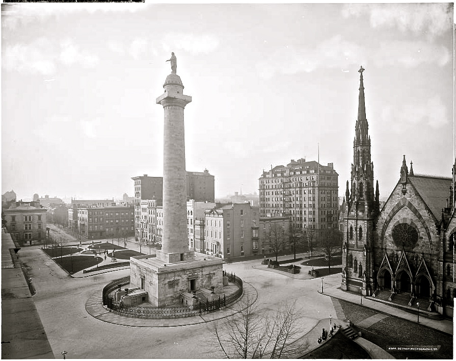
Above: Mt. Vernon Place, north and east sides, ca. 1903, by William Henry Jackson (Detroit Publishing Co.).

early 20th c. Washington Monument, Baltimore, Library of Congress/enclos*ure
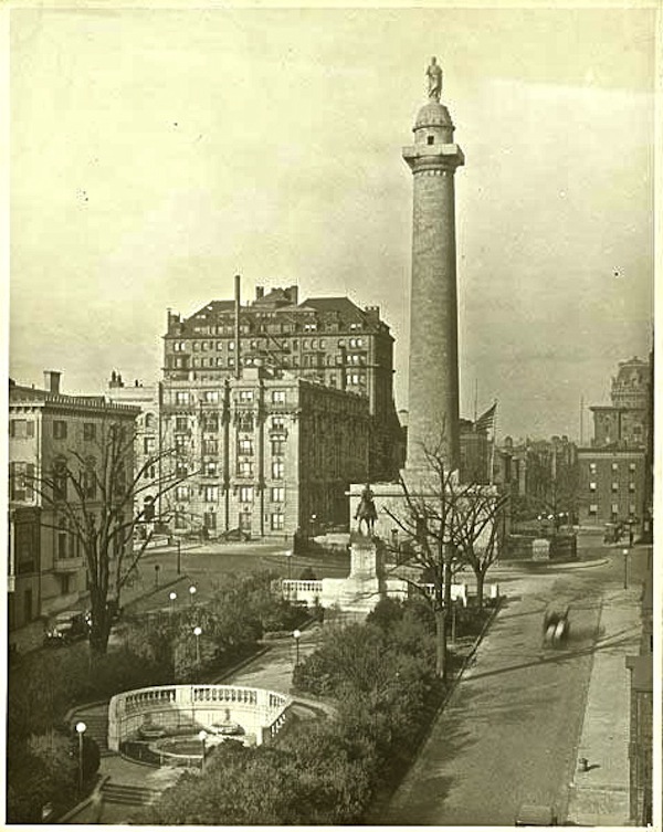
Above: Looking north, ca. 1920-1930, photographer unknown.

This last photo shows the work of Thomas Hastings of the architecture firm of Carrère and Hastings.  In 1917, he redesigned the squares in the Beaux-Art style.  According to the Mount Vernon Place Conservancy:

[His] design was an exemplar of City Beautiful-inspired architectural and landscape design, which called for symmetry, uniformity and axiality.

Hastings utilized white marble to harmonize his new work with the existing monument, and retained the tradition in the east, west and north squares of matched trees framing the squares. After his hardscape work was completed, the trees in all of these squares were replanted to ensure they would mature uniformly, creating and maintaining a crisp border on their edges. Hastings supported this wholesale replanting as necessary for the future integrity of his design.

In the south square, however, he retained some of the existing large trees and shrubs to frame out a newly positioned statue of Lafayette.

It used to be possible go inside the monument and climb to the top.  I did it about 12 years ago.  There are 228 very claustrophobic steps.  The structure has not been open to the public for the last three years, however.


*All the images here are via the Library of Congress Prints and Photos Division, except the third, fourth, and last, which are via the Maryland Historical Society.

Vintage landscape: clear sailing

Children with sailboats on the Reflecting Pool, 1920s, Library of Congress/enclos*ure“Children with sailboats at Reflecting Pool, Lincoln Memorial in background, Washington, D.C.,” in the 1920s. Photographer unknown, part of the National Photo Company Collection, Library of Congress Prints and Photographs Division.

Unfortunately, these little boats would be swamped today, as Washington is in the grip of tropical storm Andrea.

Thunder blossoms gorgeously above our heads,
Great, hollow, bell-like flowers,
Rumbling in the wind,
Stretching clappers to strike our ears . . .
Full-lipped flowers
Bitten by the sun
Bleeding rain
Dripping rain like golden honey—
And the sweet earth flying from the thunder.

— Jean Toomer, “Storm Ending

A study in steps: Muhima

Roadside steps, Muhima sector, Kigali, Rwanda/enclos*ure
Boulevard de Nyabugogo, Muhima Sector, Kigali, Rwanda.

Detail of roadside steps, Kigali, Rwanda

Sprawling over numerous hills and valleys, with roads that wind crazily around and across the contours, Kigali can be a confusing city to navigate. Just when you think you know where you are going, your destination appears on the horizon in another direction! However, it’s a fairly compact city and assuming that you aren’t put off by the idea of steep slopes, over-friendly children and changeable weather, walking is a fantastic way to get about. If you have just arrived, don’t forget that Kigali lies at an altitude of around 1,600m, so take it easy on the hills!

— Caroline Pomeroy in the Bradt guide to Rwanda

A study in steps: the High Line

High Line steps/enclos*ure

The arrangement of steps/benches at the 10th Ave. Square seems to be one of the more successful sections of the High Line — if you judge success  at least partly on the visitors’ use of and engagement with the site.

People watch the traffic with real interest, college students share snacks, couples kiss, and (perhaps a mark of a really good landscape structure) pre-teen boys find a way to engage in semi-dangerous horseplay.

High Line steps/enclos*ure

Below: the windows overlook northbound 10th Ave.  (Click any photo for a clearer, larger view.)

High Line steps/enclos*ure

Below: at the back, the High Line walkway continues toward the Chelsea Market Passage.High Line steps/enclos*ure

High Line steps/enclos*ure

High Line steps/enclos*ure

Above and below:  the traffic becomes really interesting when framed out as if on a screen.High Line steps/enclos*ure

Below:  the blue billboard over the avenue is a work of art commissioned for the High Line.High Line steps/enclos*ure

High Line steps/enclos*ure

High Line steps/enclos*ure

Below: the boys were long-jumping from bench to bench.High Line steps/enclos*ure

Above and below:  there’s a little tripping hazard at this turn (in the center of the photos — click to enlarge).  It looks there just wasn’t enough room for the angle to run out.High Line steps/enclos*ure

High Line steps/enclos*ure

Below:  looking up.High Line steps/enclos*ure

High Line steps/enclos*ure

High Line steps/enclos*ure

High Line steps/enclos*ure

To scroll through a gallery of larger images, click on ‘Continue reading’ below.


A walk along the High Line in April

The High Line, NYC/enclos*ure

I want to share my photos from our walk along the High Line in New York City last month.

It was actually our second walk — I left my camera behind on the first. It’s such a remarkable place that my husband, who has limited patience for garden tourism, readily agreed to go back with me.

The High Line is a meadow and woodland park on top of about a mile of abandoned elevated railway line.

It trails through an crowded urban landscape and rather than offer you a retreat from the city, it puts you right up in the city’s face — with apartment windows and construction sites almost within touch and noisy traffic moving below.  The juxtaposition is thought-provoking, and the raised views are fascinating.

The High Line, NYC/enclos*ure

In early April, of course, we weren’t seeing most of the plants at their best, but it was interesting to see so clearly the arrangement and spacing of the grasses, some emerging perennials, and the shrubs and small trees — as well as the features of the built structure.

The High Line’s planting plans were designed by Piet Oudolf, and  I found a good summary of his approach to the meadow areas in an article by Tom Stuart-Smith in The Telegraph.

For Oudolf, planting has always been about creating moods and eliciting emotions. But the [High Line] gains an extra weight by connecting us to how plants grow in the wild. The design becomes much more about creating a plant community rather than a collection of individuals. To take one section of planting . . . , the plan shows a loose matrix of grass species planted throughout; in this case a mix of Panicum virgatum ‘Heiliger Hain’ and Calamagrostis brachytricha spaced about 1-1.5m apart with about 20 other varieties of perennial flower spread through in different-sized groups, from one plant used just singly to another planted in generous groups. The flowers therefore are always seen within a matrix of grasses, just as they might be in nature.

The full article — related to the recent publication of the book Planting, A New Perspective — is very interesting about Oudolf’s technique and influence.

The High Line, NYC/enclos*ure

I found my photos weren’t very useful at a few inches wide, so please click on the first thumbnail below to scroll through full-size images.

(The plants of the High Line aren’t labeled, but, you can download a list to take with you here.)