In Amalfi


This slideshow requires JavaScript.

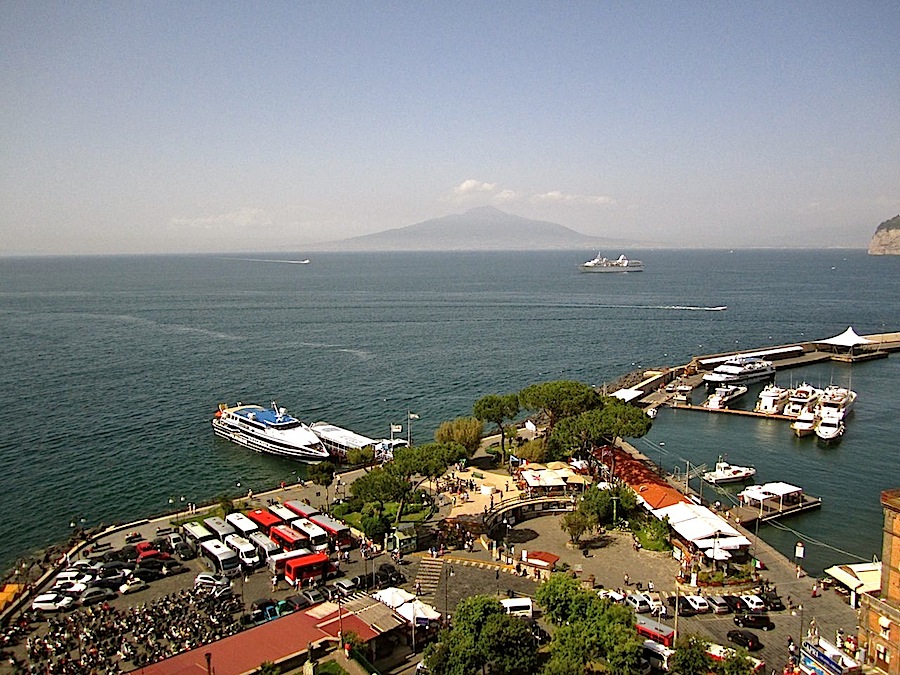
Two Saturdays ago, we were just beginning a brief vacation in Italy, in  Sorrento on the Bay of Naples.

On Sunday, as a day trip, we took a local bus along the winding, narrow, cliff-hanging road that edges the gorgeous Amalfi Coast.

We rode it all the way to Amalfi itself– an important city back around the first millennium A.D., but now just a very pretty coastal resort selling hand-painted ceramics and products made from lemons.

The little strip of grey pebbles and fist-sized rocks that is Amalfi’s “beach” did not impress us, but the sparkling blue, clear-to-the-bottom water was very inviting.

There is one main street, which runs straight back from the sea and up into the surrounding hills about a half mile. On either side above it, houses and small lemon groves cling to steep slopes, connected by an extensive web of covered and open alleyways and steps.

The duomo or cathedral is the town’s major site. It was constructed and re-constructed from the 9th to 19th centuries and displays a mix of Norman-Arab Romanesque, Gothic, Byzantine, and Baroque architecture styles.

The photos above are of its Cloister of Paradise, built in 1268 as a gravesite for local wealthy merchants. The Arab style of the beautiful simple arches is not surprising, given Amalfi’s close ties during the Middle Ages with Arab traders throughout the Mediterranean (not excluding traffickers in European slaves).

Pretty as the cloister was, however, I have to say that my favorite Amalfi garden was this tiny terrace (below). Its horizontally espaliered lemon trees were guarded by a Roman soldier and the seven dwarves.


This slideshow requires JavaScript.

Visiting Sorrento and the Amalfi Coast

Travel writer Rick Steves says this about Sorrento:

The Sorrentines have gone out of their way to create a completely safe and relaxed place for tourists to spend money. . . . Spritzed by lemon and olive groves, this gateway to the Amalfi Coast has an unspoiled old quarter, a lively main shopping street, [and] a spectacular cliffside setting.

That’s pretty much what we wanted for the first two nights of our vacation, and that’s what we got.   Like Amalfi, aside from tourism, the city is now mainly known for growing impressively large lemons.  Its limoncello is supposed to be the best.  (Although I think it tastes like an alcoholic lemon drop, much too sweet; Amaro is my Italian digestive of choice.)

A swimming area along the Sorrento waterfront.
Getting around . . . train

To get to Sorrento from the Naples train station (Stazione Centrale), follow the signs leading downstairs to the platform for the Circumvesuviana commuter train.  Tickets are only €4.10 and can be purchased right at the turnstile.  Make sure you get on a train marked “Sorrento.”  They leave every half hour.

The Circumvesuviana was the only place where we had any problem with crime during our trip.  The platform was very crowded, and almost as soon as we entered the train, a pickpocket tried to take my husband’s wallet. After that, he kept his credit card and money in a small zippered bag with a loop attached to his belt — something like this.

We were each traveling with a rolling carry-on bag and a “personal item.”  This is the most I would ever try to keep track of on this train.

From the Sorrento train station, it’s an easy walk to the historic part of the city.

Boat

To return to Naples, we walked to the Sorrento piers and took one of the fast hydrofoil boats. The boats leave about every two hours, and you don’t need a reservation. (From the same place, there are also boats to Amalfi, Positano, and Capri.)

To buy the €15 ticket, go to the sunken semi-circle area in the photo below, consult the extensive, yet unrevealing signage to the find the correct line, and then ask for a one-way on the “Jet”  to Calata Beverello-Naples (a brief walk away from the Piazza Plebiscito).  The view of Naples as you arrive by water is lovely.

That's Mt. Vesuvius in the center.
That’s Mt. Vesuvius in the center.
Bus

The SITA bus that took us to Amalfi and back was a bargain thrill ride (the road is often only one and a half lanes wide) at €6.80 for all-day, on-and-off access. Buses leave Sorrento, Positano, and Amalfi about every hour (but not 24 hours, so check the schedule for the time of the last bus). The Sorrento-Amalfi trip takes one to two hours, depending on traffic.  In Sorrento, tickets are sold at the SITA bus stop in front of the train station.  The buses are blue, except when they’re red.

Hotel and restaurants

We stayed at the Hotel Rivoli in Sorrento, right in the center of the historic area.  The rooms were simple, clean, and comfortable.  The staff were very helpful with directions and advice.  The €5 breakfast offered croissants, cereal, and fruit, plus enough sweets to fill out a respectable Christmas buffet table.

We arrived in Sorrento after 24 hours of travel and by 6:15 p.m., we were exhausted.  At that very un-Italian dinner hour, L’Antica Trattoria served us their three-course “light lunch” very graciously.  Given the high quality of the food, it was a bargain at €20 each. We also had a very good meal the next night at the more unassuming Ristorante O’ Murzill’ at Via Dell’ Accademia, 17.

.   .   .  borne on
Beyond Sorrento and Amalfi, where
The Siren waits thee, singing song for song.

— Walter Savage Landor, from “To Robert Browning

Vintage landscape: Poca, WV

Vintage landscape/enclos*ure: Poca, W.V., 1973,, via Natl. Archives“Water cooling towers of the John Amos Power Plant* loom over Poca, [West Virginia], home that is on the other side of the Kanawha River. Two of the towers emit great clouds of steam.”

This photo† (shown here with original caption) was taken in August 1973 by Harry Schaefer for DOCUMERICA, a photography project of the U.S. Environmental Protection Agency.

There are more pictures from DOCUMERICA here.


*Three-unit coal-fired power plant.

†Via the U.S. National Archives Commons on flickr.

Neptune Road, Boston

Life in gardens/enclos*ure: East Boston, 1973, by M.P. Manheim, via Natl. ArchivesA woman turns her garden soil while a Massachusetts Bay Transit Authority train rushes past the northeastern side of Neptune Road in East Boston, Massachusetts.

This photo* was taken in May 1973 by Michael Philip Manheim for the DOCUMERICA program of the Environmental Protection Agency.

Manheim captured East Boston, particularly around Constitution Beach and Neptune Road, at a moment of massive expansion of transportation infrastructure, including Interstate 90 (which terminates in East Boston) and an above-ground portion of the city’s rail system (both projects completed in the 1950s). But more than any other piece of infrastructure, Logan Airport was the source of the biggest and potentially most harmful changes.

Logan’s expansion in the mid-1960s led to the removal of a Frederick Law Olmsted-designed park (Wood Island park), and its 1970s expansion led to the displacement of residents on Neptune Road as well as mounting local noise and air pollution issues.

Forty years later, the lively neighborhood Manheim found along Neptune Road hardly exists, replaced with parking lots and runways.

— Mark Byrnes, for the CITYLAB blog of The Atlantic

There are more photos of East Boston by Manheim  here.


*Via the U.S. National Archives Commons on flickr.

Jamaica Bay, New York

Vintage landscape/enclos*ure: Jamaica Bay vegetable garden, 1973, by A. Tress, via National ArchivesBroad Channel, marginal land in Jamaica Bay near the JFK Airport. New York City owns this land and leases it for five year periods. This renter is cultivating a vegetable garden.”

Arthur Tress took this picture* in May 1973 for DOCUMERICA, a program of the U.S. Environmental Protection Agency, which “photographically document[ed] subjects of environmental concern” from about 1972 to 1977.

Note that the house is raised on pilings, as well as the walkway from the back door to the garden.

There are more pictures from DOCUMERICA here.


*Via the U.S. National Archives Commons on flickr. Caption by photographer or EPA.

Life in gardens: conversation

This slideshow requires JavaScript.

I like this trio of photos by Louise Rosskam, which capture two men on a town common bench evidently enjoying a funny story or joke.

They were  taken in Vergennes, Vermont, in August 1940.*

New England commons were (and are) community spaces that probably evolved from the lots originally set aside for village meetinghouses or churches.  After the mid 19th century, many began to function like parks.†

Although Rosskam was not employed there, a series of photos that she took in rural Vermont became part of the picture archives of the Farm Security Administration.

In a 1965 oral history interview, she related how she proposed taking these pictures for the FSA, where her husband, Edwin, was a photo editor.

. . . [O]nce I took a vacation in Vermont, and I said to Roy [E. Stryker, head of the Information Division],”Could I take some pictures for you?” you know, “I’ll buy my own film and everything.” And he said, “Oh, here’s some film,” and then he starts rambling along about Vermont and really it didn’t sound as if it had anything to do with what you wanted to do at all. You started talking about hills, farmhouses and how people build a little extension on the house for the old people, and about pickled limes, the sky and how to get to Vermont 50 years ago, you know; by the time you got through listening to him ramble along, you begin to get some sort of formation in your mind of what there was up there so that when you get out there (phone rings)-

LOUISE ROSSKAM: (continues after phone conversation) But I’m sure that everybody sitting around, listening to Roy ramble, as it seemed, began to get his mind turned in the direction to be open to a lot of things that ordinarily he wouldn’t perceive when he got to a place. Don’t you think that’s true?

For many years afterward, her Vermont photos were attributed to her husband.  The records were corrected in 2001.

Laura Katzman, an associate professor of art history at James Madison University, curated two exhibits of Louise Rosskam’s photos and described her work like this:

She was one of those documentary photographers for whom the people and the work were so much more important than her name or her career. . . .  She tried to erase herself as much as possible. It was a pure documentary ideal that was impossible to achieve: let the subject feel comfortable, take yourself out of it and see what happens in the encounter. She did this beautifully because her ego wasn’t invested in it.

You can see four more photos by Rosskam of the Vergennes common by clicking on ‘Continue reading’ below.


*All via the Library of Congress Prints and Photographs Division.

†Vergennes is actually a city — the first chartered in Vermont and currently its smallest (in population). It is approximately 2.5 sq. miles in area.