 “[S]chool yard, Jindalee Primary School, [Cootamundra, Australia,] c. 1920s,” photographer unknown; via State Library of New South Wales Commons on flickr.
The children have made a map of the world in dirt. It includes cut-out ships and animals.
“[S]chool yard, Jindalee Primary School, [Cootamundra, Australia,] c. 1920s,” photographer unknown; via State Library of New South Wales Commons on flickr.
The children have made a map of the world in dirt. It includes cut-out ships and animals.
 Man and woman work in front of a joint sod hut covered in grass and flowers, near the village of Vestre Jakobeselv, Norway. Taken 1900 by Ellisif Rannveig Wessell, via Preus Museum Commons on flickr.
Living in Finnmark, in the far northeastern part of Norway, Wessel photographed the hard lives of its rural poor. The Preus Museum — Norway’s national museum of photography — compares her to Jacob A. Riis and Lewis Hine.
She developed her own glass plates and used sunlight to make her prints.
Warm summer sun,
Shine kindly here,
Warm southern wind,
Blow softly here.
Green sod above,
Lie light, lie light.
Good night, dear heart,
Good night, good night.— Mark Twain, “Warm Summer Sun“
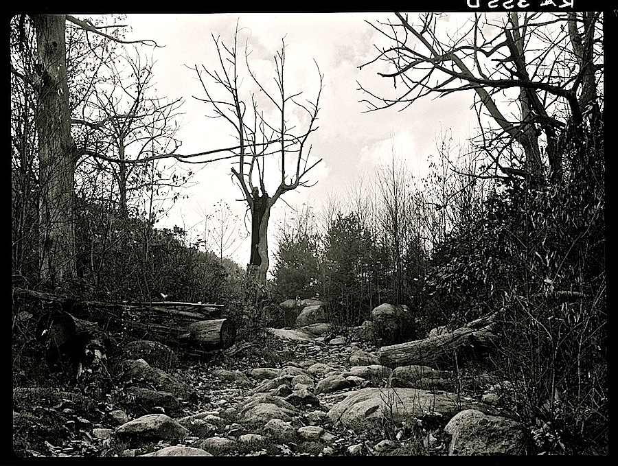 “Road to Nicholson Hollow. Shenandoah National Park, Virginia,” October 1935, by Arthur Rothstein, via Library of Congress Prints and Photographs Division.
I think this would be a good reference picture for making a dry stream bed path through a naturalistic garden (click to enlarge).
More on Nicholson Hollow this Sunday. . . .
Nel mezzo del cammin di nostra vita
mi ritrovai per una selva oscura
che la diritta via era smarritaThe Divine Comedy – Pt. 1 Inferno – Canto 1 – (1-3)
13. In the middle of the journey
of our life
I came to myself
In a dark forest
The straightforward way
Misplaced.
(Schwerner, 2000)— Caroline Bergvall, from “VIA” (48 Dante Variations)
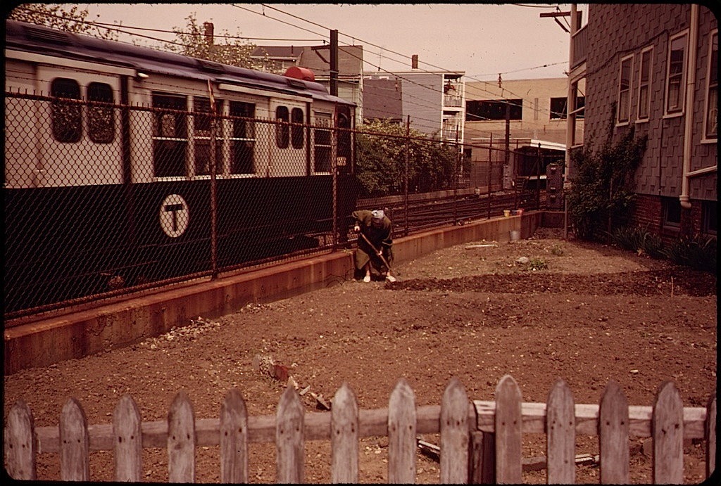 A woman turns her garden soil while a Massachusetts Bay Transit Authority train rushes past the northeastern side of Neptune Road in East Boston, Massachusetts.
This photo* was taken in May 1973 by Michael Philip Manheim for the DOCUMERICA program of the Environmental Protection Agency.
Manheim captured East Boston, particularly around Constitution Beach and Neptune Road, at a moment of massive expansion of transportation infrastructure, including Interstate 90 (which terminates in East Boston) and an above-ground portion of the city’s rail system (both projects completed in the 1950s). But more than any other piece of infrastructure, Logan Airport was the source of the biggest and potentially most harmful changes.
Logan’s expansion in the mid-1960s led to the removal of a Frederick Law Olmsted-designed park (Wood Island park), and its 1970s expansion led to the displacement of residents on Neptune Road as well as mounting local noise and air pollution issues.
Forty years later, the lively neighborhood Manheim found along Neptune Road hardly exists, replaced with parking lots and runways.
— Mark Byrnes, for the CITYLAB blog of The Atlantic
There are more photos of East Boston by Manheim here.
*Via the U.S. National Archives Commons on flickr.
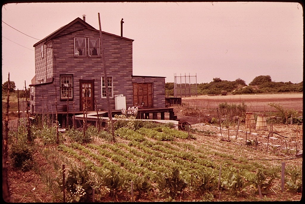 “Broad Channel, marginal land in Jamaica Bay near the JFK Airport. New York City owns this land and leases it for five year periods. This renter is cultivating a vegetable garden.”
Arthur Tress took this picture* in May 1973 for DOCUMERICA, a program of the U.S. Environmental Protection Agency, which “photographically document[ed] subjects of environmental concern” from about 1972 to 1977.
Note that the house is raised on pilings, as well as the walkway from the back door to the garden.
There are more pictures from DOCUMERICA here.
*Via the U.S. National Archives Commons on flickr. Caption by photographer or EPA.
