The Sunday porch: Mount Toxaway

2 The Sunday porch:enclos*ure -- Lake Toxaway, c. 1902, Library of Congress
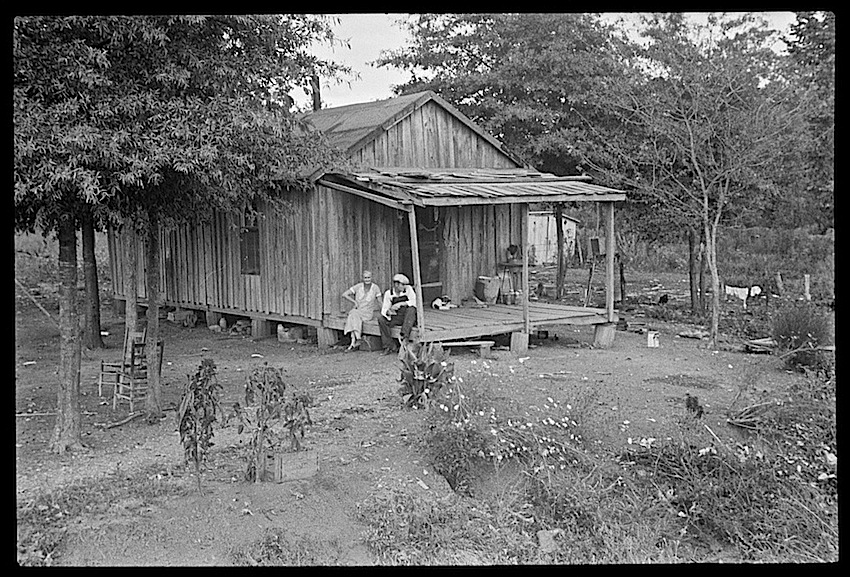
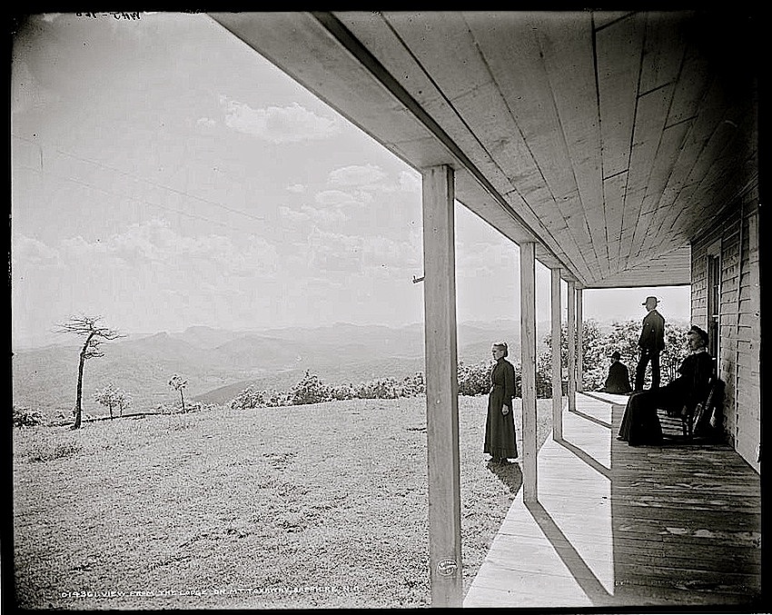
The Lodge on Mount Toxaway, Sapphire, North Carolina, ca. 1902, by William Henry Jacksonvia Library of Congress Prints and Photographs Division (all photos here).

The Lodge was part of the Toxaway System of Hotels, created by a group of Pittsburgh entrepreneurs who began to built resorts in the Sapphire area in the 1890s.

By 1903, they had dammed the Toxaway River — creating the 640-acre artificial Lake Toxaway — and constructed the luxurious 500-guest Toxaway Inn.  After 1904, when the Southern Railroad opened a depot on the lake, the area was known as “Switzerland of America.”

1 The Sunday porch:enclos*ure -- Lake Toxaway, c. 1902, Library of Congress

The Lodge was presented in a 1905  company brochure as a “nature kindergarten” for “children of the city” to learn about trees, flowers, and birds. Farm animals and poultry were also available for study.

4 The Sunday porch:enclos*ure -- Lake Toxaway, c. 1902, Library of Congress

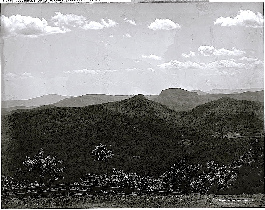
At an altitude of over 4,500 ft., the views from the wrap-around porch and the lookout tower were particularly good. Guests from the other Toxaway hotels would spend the night in the house to see the sunrise or sunset over the mountains.

It was also used as a hunting retreat for wealthy industrialists.

3 The Sunday porch:enclos*ure -- Lake Toxaway, c. 1902, Library of Congress

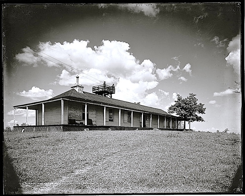
The Lodge no longer exists — although it  was still there in 1920, four years after severe flooding caused the company’s dam to burst. (Some homes were destroyed, but only a mule perished.)

Lake Toxaway disappeared, and the Toxaway Inn emptied out as well. It never re-opened after 1916 and was demolished in 1947.

In the early 1960s, another group of investors rebuilt the dam. The lake re-filled, and a golf club and hotel were opened. The property around what was once The Lodge is now  Preserve at Rock Creek, an “exclusive” real estate development.

To scroll through larger version of the photos, click on ‘Continue reading’ below and then on any thumbnail in the gallery.

My mind was once the true survey
Of all these meadows fresh and gay,
And in the greenness of the grass
Did see its hopes as in a glass. . .

— Andrew Marvell, from “The Mower’s Song

The Sunday porch: irises

Japanese Iris GardenTwo women in a pavilion overlooking irises in Japan, between 1860 and 1910.

Japanese Iris Garden, cropped 1
Detail of photo above.

This hand-colored photograph comes from the National Museum of Denmark Commons on flickr — part of a collection that belonged to journalist Holger Rosenberg.

Unfortunately, the museum does not have any additional information about it.

Japanese Iris Garden, cropped 2
Detail of top photo. The flowers are probably growing in slightly sunken, wet or damp ground.

In Heian Period [794 -1185] Japanese gardens, built in the Chinese model, buildings occupied as much or more space than the garden. The garden was designed to be seen from the main building and its verandas, or from small pavilions built for that purpose. In later gardens, the buildings were less visible. Rustic teahouses were hidden in their own little gardens, and small benches and open pavilions along the garden paths provided places for rest and contemplation. In later garden architecture, walls of houses and teahouses could be opened to provide carefully framed views of the garden. The garden and the house became one.

— “Japanese garden,” Wikipedia

Click here to see all the Museum’s online photos of Japanese landscapes (and some wonderful kimonos).

There’s also a 1913 Japanese iris garden in East Hampton, N.Y., here.

To scroll through larger versions of these images, click on ‘Continue reading’ below and then on any thumbnail in the gallery.

The Sunday porch: Delta Farm

Front porch, Delta Coop Farm, 1937, Library of CongressThe front porch of a Delta Farm home, Hillhouse, [Bolivar County,] Mississippi,” June 1937, by Dorothea Lange, via Library of Congress Prints and Photographs Division (all photos here).

Delta Cooperative Farm was a privately owned and administered agricultural resettlement project for white and African-American sharecroppers evicted in the mid-1930s.

Founded in 1936 by several religious thinkers, educators, and organizers — including well-known missionary author Sherwood Eddy, who had $20,000 to spend from a follower — the enterprise avowed a commitment to economic equality among the races.

Over half of the first group of 31 farmers to settle at Delta were Black. All members worked together to grow cotton and cut and mill the land’s cypress timber.  All of them shared in the first year’s profits: $327 per family.

Delta Coop Farm houses, 1937, Library of Congress

The farm’s small houses had the same simple plan and amenities — “Screen windows and porches are uncommon in cotton cabins,” noted Lange — but they were segregated in two rows: one white, one African-American, separated by a road. And the children attended segregated schools.

All the families shared the produce of a 10-acre vegetable garden, however, which appears in the photos above to have engulfed the cabins.

And they all used the farm’s clinic, nursery, and library and attended the integrated cooperative meetings.  There had to be at least two Black members on the five-person farm council.

Delta Coop Farm, 1937, Library of Congress

At the start of World War II, the project lost members to wartime industry jobs and military enlistment, and, in 1942, the land was sold.

Four years before, in 1938, the Delta trustees had established a second inter-racial farm project in Mississippi — Providence Cooperative Farm in Holmes County. It operated until 1955, when its staff and residents fled after being threatened by the white citizens of nearby Tchula.  The empty land was sold the following year.

You can read a more complete story of the two visionary cooperative farms here.

The Sunday porch: Dyess Colony

Porch, Dyess Colony, Arkansas, 1940, Library of CongressBeautiful elephant ears. This porch belonged to a farming family who were “resettled” in “Colonization Project No. 1” in Mississippi County, Arkansas.

The photos* were taken in August 1935 by Arthur Rothstein. He was on assignment for the U.S. Farm Security Administration.

Children, Dyess Colony, Arkansas, 1940, Library of Congres

The government-sponsored agricultural community had just been established the year before — the brainchild of local cotton planter William Reynolds Dyess, who was also Director of the Arkanasas Emergency Relief Administration.

Family, Dyess Colony, Arkansas, 1940, Library of Congres

Dyess wanted to provide aid to displaced tenant farmers and sharecroppers. His idea was to put 800 families on 20 to 40-acre uncleared bottomland plots with new houses.

Dyess Colony, Arkansas, 1940, Library of Congres

The project — scaled back to 500 families — was underwritten by the New Deal Federal Emergency Relief Administration. (It was absorbed by the Farm Security Administration in 1944 and made independent of the federal government in 1951. )

“The colony was laid out in a wagon-wheel design, with a community center at the hub and farms stretching out from the middle. . ,” according to the online Encyclopedia of Arkansas. “Each house had five rooms with an adjacent barn, privy, and chicken coop. . . , plus a front and back porch.”

Another Dyess Colony House, Arkansas, 1935, Library of Congress
Another colony house with a mass of flowers along the front path.

Dyess was killed in a plane crash in 1936, and the colony was given his name.

Among the resettled farmers — all of whom were white — was the father of country singer Johnny Cash.  Cash lived  in house #266 from the age  of three until his high school graduation in 1950.

Today, Arkansas State University has restored the Cash home (open to the public) and is working on an adjacent original colony home, as well as the administration building and theater.

Sharecropper's house, Dyess Colony, Arkansas, 1935, Library of Congress

The 1935 photo above by Ben Shahn was captioned, “Sharecropper’s house optioned. Dyess Colony, Arkansas.”  I’m not sure what that means, but the picture gives an example of original local farm housing.

I like the small semi-circle of trees and the two chairs facing out on the left side.


*All photos but the last were by Rothstein, taken in August 1935. All are via Library of Congress Prints and Photographs Division.

The Sunday porch: Eutaw

Eutaw, S.C., 1938, Library of Congress“The Lodge” at Eutaw Plantation, Berkeley County, South Carolina, 1938, by Frances Benjamin Johnston, via Library of Congress Prints and Photographs Division.

Eutaw Plantation, South Carolina, 1938, via Library of Congress
The plantation was established by William and Elizabeth Sinkler in the early 1800s.  Their descendants owned it until the 1940s, when the South Carolina Public Service Authority flooded the area to build the Santee Cooper hydroelectric project.  The estate now lies beneath Lake Marion.

The Lodge — built to resemble a Greek temple — was used as a medical office by a physician member of the family.

I came to explore the wreck. . . .
I came to see the damage that was done
and the treasures that prevail.

Adrienne Rich, from “Diving into the Wreck